Les Adrets | |
|---|---|
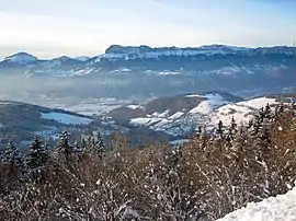 Les Adrets and the Chartreuse, seen from Prapoutel | |
.svg.png.webp) Coat of arms | |
Location of Les Adrets | |
 Les Adrets  Les Adrets | |
| Coordinates: 45°16′21″N 5°57′55″E / 45.2725°N 5.9653°E | |
| Country | France |
| Region | Auvergne-Rhône-Alpes |
| Department | Isère |
| Arrondissement | Grenoble |
| Canton | Le Haut-Grésivaudan |
| Intercommunality | CC Le Grésivaudan |
| Government | |
| • Mayor (2022–2026) | Delphine Perreau[1] |
| Area 1 | 16 km2 (6 sq mi) |
| Population | 1,068 |
| • Density | 67/km2 (170/sq mi) |
| Time zone | UTC+01:00 (CET) |
| • Summer (DST) | UTC+02:00 (CEST) |
| INSEE/Postal code | 38002 /38190 |
| Elevation | 560–2,440 m (1,840–8,010 ft) |
| 1 French Land Register data, which excludes lakes, ponds, glaciers > 1 km2 (0.386 sq mi or 247 acres) and river estuaries. | |
Les Adrets (French pronunciation: [le.z‿adʁɛ]) is a commune in the Isère department in southeastern France. It is situated 30 km (19 mi) northeast of Grenoble. It is one of the commune of the Les sept Laux winter sports resort.
Population
| Year | Pop. | ±% p.a. |
|---|---|---|
| 1968 | 282 | — |
| 1975 | 297 | +0.74% |
| 1982 | 409 | +4.68% |
| 1990 | 481 | +2.05% |
| 1999 | 643 | +3.28% |
| 2007 | 743 | +1.82% |
| 2012 | 938 | +4.77% |
| 2017 | 1,006 | +1.41% |
| Source: INSEE[3] | ||
See also
References
- ↑ "Répertoire national des élus: les maires" (in French). data.gouv.fr, Plateforme ouverte des données publiques françaises. 6 June 2023.
- ↑ "Populations légales 2021". The National Institute of Statistics and Economic Studies. 28 December 2023.
- ↑ Population en historique depuis 1968, INSEE
Wikimedia Commons has media related to Les Adrets.
This article is issued from Wikipedia. The text is licensed under Creative Commons - Attribution - Sharealike. Additional terms may apply for the media files.